County Readies to Revive Savannah River National Scenic Byway
Greg Wilson/Anderson Observer
The Savannah River Scenic Byway has been hiding in plain sight for 28 years.
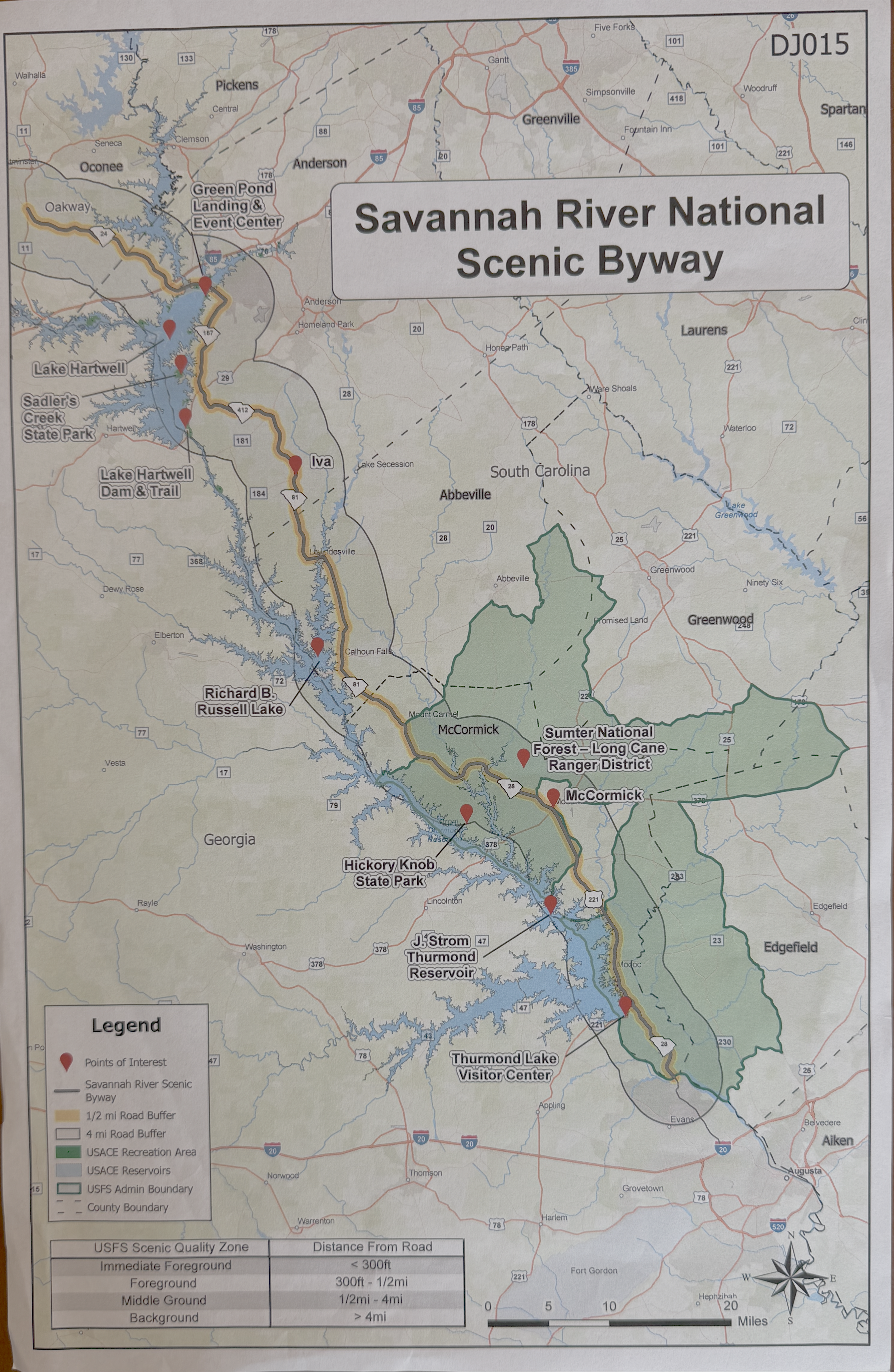
Designated in 1998 as a 110-mile National Scenic Byway, the route runs from Oakway/SC-24 near SC-11 in Oconee County to Clarks Hill, near the Georgia border, following South Carolina’s western edge through lake country, rural communities, dam sites, historic towns, and the larger landscape shaped by the Savannah River. About 39-40 miles of the byway runs through Anderson County, yet most residents would be hard pressed to identify it on a map or find a single roadside sign announcing that they are driving it.
Dennis Tobin, Anderson County’s deputy director of Planning and Community Development, calls it a “sleeping dragon.” The designation was never formally revoked, it simply became dormant after the state’s broader heritage-corridor initiative drew the attention, funding, signs, and institutional energy that might otherwise have gone to the linear scenic route.
“There’s the heritage corridor,” Tobin said. “They started and then they hijacked it, overshadowed us. And they put this one to sleep.” The heritage corridor, he explained, is a broader, county-scale concept. A scenic byway is more focused, following a particular route and emphasizing what travelers can see, experience, and reach from the road.
That distinction has become important again as Anderson County attempts to revive the byway as part of its new comprehensive plan. County Council approved the plan in May, including Chapter 6, which identifies reactivation of the Savannah River Scenic Byway as a policy goal. Now, county leaders are preparing a resolution to formally recognize the route at their regular meeting Tuesday, which would be before National Scenic Byway Day on Sept. 22.
The federal scenic-byway program grew from a 1993 initiative to identify and protect exceptional routes across the country. To qualify, a byway needed to demonstrate at least two of six “intrinsic qualities:” scenic, historic, archaeological, cultural, recreational, and natural significance.
In the 1990s, “scenic” and “historic” were often the default categories, Tobin said. But the Savannah River route has acquired a different identity over time: recreation. The growth of boating, fishing, hiking, camping, dam tours, lake access, and tournament activity — may now be its most powerful argument.
The 1998 designation required a corridor management plan, a document that described the route, its resources, its significance, and the means of protecting it. That original plan recommended that Anderson County include the byway in its comprehensive plan within five years.
“Guess what?” Tobin said. “After 28 years, we’re doing it now.”
The delay was not caused by the road disappearing, the byway remained intact even without its public identity. Its route still moves through largely rural and lake-oriented landscapes, it still offers access to historic sites, forests, reservoirs, small towns, and recreation areas. What it lacks is the apparatus of recognition: consistent signs, a modern web presence, a local advocacy structure, an updated interpretation of its assets, and a coordinated plan among counties and tourism groups.
One reason the byway’s revival may be better timed now than it was in 1998 is that some of its defining landmarks have aged into history.
When the original corridor plan was written, the Hartwell, Richard B. Russell, and J. Strom Thurmond dams were still relatively recent feats of federal infrastructure. Hartwell was completed in 1962, Russell in 1984, and Thurmond in 1953. They were built for flood control, hydropower, water management, and recreation. Today, Tobin argues, they also tell the story of a now-closed chapter in American development.
“We will never see another dam built like this again,” he said.
The dams, reservoirs, visitor centers, and power facilities form what Tobin calls a “life story” of the postwar era — an infrastructure landscape that spans the Baby Boom generation. A traveler can visit Thurmond Dam and its visitor center, observe the power plant at Russell, or see Hartwell Dam and its surrounding recreation areas. The byway provides a way to connect those sites rather than treating them as isolated attractions.
The route is not a scenic drive in the Rocky Mountain sense, where the drama is visible through the windshield every minute. Tobin said it is quieter and more participatory. Travelers may need to pull over, park, walk toward a dam overlook, visit a town along the way, explore a cemetery or historic church, or leave the highway to understand what the landscape holds.
“It’s the type of byway where you have to drive, park your car, and walk a half mile in or something to see the dam,” he said. “But this is quiet.”
The reactivation effort has also given Anderson County a way to place Green Pond Landing at the beginning of the story rather than near its margin. Green Pond Landing, opened in 2014, has become an internationally recognized fishing venue and a centerpiece of Anderson County’s outdoor-tourism strategy. During work on the comprehensive plan, Tobin and county GIS staff determined that Green Pond Landing falls within the byway’s middle-ground viewing area.
That connection matters because Green Pond Landing is now tied to the county’s growing presence of the Bassmaster Classic, which Visit Anderson recently secured for a record fifth event. County planners hope see these tournaments as an opportunity to introduce visitors to more than the launch ramp, boats, and weigh-ins.
The hope is that Bassmaster visitors, especially those waiting for competitors or looking for a low-cost day trip, will be encouraged to explore the byway, visit small towns, stop at historic sites, and spend money along the route. Joan Holliday, Anderson County’s Planning and Community Development coordinator, said a future kiosk at Green Pond could help direct visitors toward those opportunities.
“While all those people are sitting out there waiting for the world,” Holliday said, “we’ll have that kiosk hopefully by then. And if they look online for something to do, hopefully they’ll take advantage of that. And hopefully, it’ll help the little towns they’ll stop in along the way.”
The byway’s renewed description will emphasize not only dams and historic sites but its identity as South Carolina’s “freshwater coast,” a phrase used in the original materials and now being revived by county planners.
The route begins near Interstate 85 and ends near Interstate 20, two highways that increasingly represent the congestion and rapid growth reshaping the Upstate. By contrast, the byway offers what Tobin calls “a nice place to decompress” and to a drive through land that remains, despite growth pressures, surprisingly close to the condition that justified its designation in 1998.
“For the large part, this is still as it was when it was approved. So, it’s worth recognizing, saving.”
The county hopes to add official byway signs and eventually install the interpretive kiosk at Green Pond Landing. Visit Anderson is working on a web presence, while the National Scenic Byway Foundation has already updated the route’s national listing.
County planners are joining the National Scenic Byway Foundation as a “champion member.” They plan to compete for national recognition as a reactivated byway — a relatively unusual designation because most byways either remain active or disappear entirely from public consciousness.
The immediate work is modest and is already funded. This will include a county resolution, signs, web information, a kiosk, local outreach, and a leadership workshop that county officials hope to host with the National Scenic Byway Foundation around the next Bassmaster event next March.
Tobin expects that other counties along the corridor — including Oconee, Abbeville, and McCormick — may become involved as the effort develops. The byway also connects at its northern end to the Cherokee Foothills Scenic Highway, creating the possibility of a larger scenic and heritage network across the Upstate.
The project does not require a new highway, a large staff, or a major recurring budget. The road exists. The scenery exists. The dams, lakes, historic sites, small towns, fishing grounds, and visitor centers already exist. What is needed, Tobin said, is recognition, coordination, and what he called “a little sweat equity.”
“Maybe that’s why it’s good it waited all these years,” he said. “We put it off all these years to just put some sweat equity and backbone. There’s not a lot of cost. It’s already there, and it’s still preserved.”
For a byway that spent nearly three decades as an official but largely invisible route, the next step is unusually simple: wake it up.